
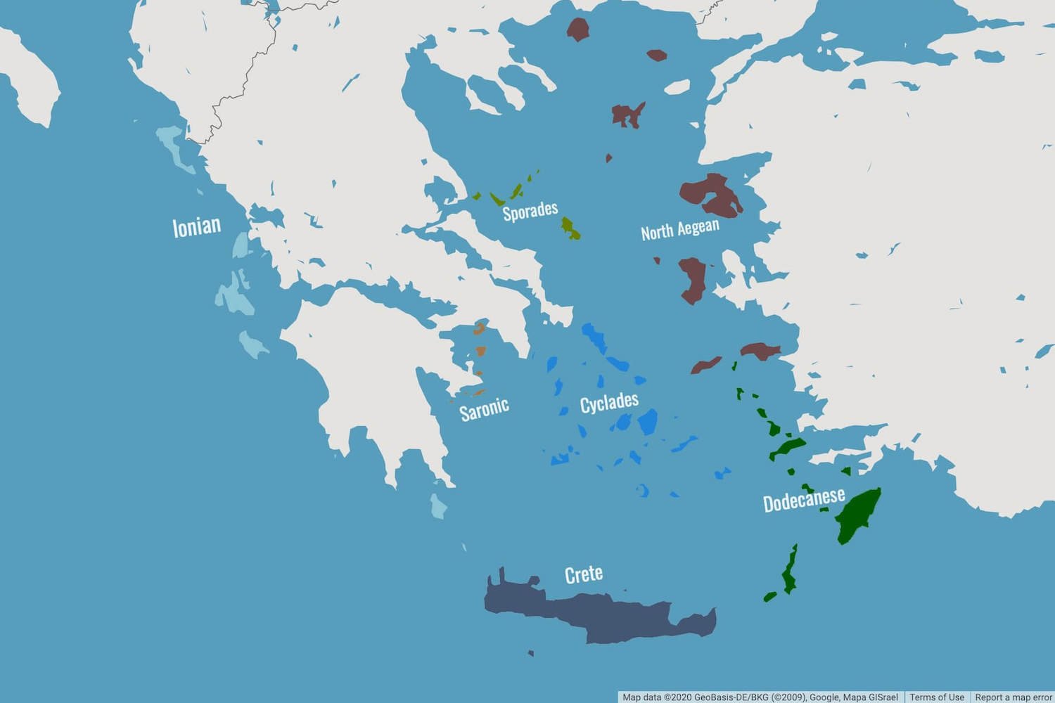
Greece’s thousands of islands are spread over the eastern Mediterranean Sea. They are grouped into six main island groups; the Cyclades, the Ionian Islands, the Sporades, the Dodecanese, the Saronic Islands, and the North Aegean Islands. Evia and Crete are typically left out of the grouping and sit on their own due to their size. The entire map of the Greek Islands can be split out to show the detailed maps of the individual island groups, which you will see below.
The over-200 inhabited Greek islands are grouped geographically. Not surprisingly, each of the island groups have their own distinguishing features. From the lush green landscapes of the Ionian islands, to the minimalist whitewashed architecture of the Cyclades and the strong medieval influences of the Dodecanese.
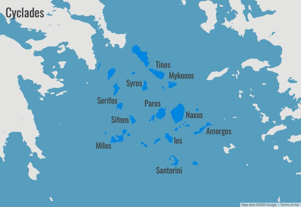
The Cyclades
The Cyclades are what you might consider unmistakably characteristic and picturesque. The most well known Greek island group, comprising the wildly popular islands of Mykonos, Santorini and Paros.
The Cyclades are easily accessible via direct flights from the UK and Europe. Connecting flights via Athens are also popular, with the Cyclades having a number of islands with domestic airports.
Due to their location in the heart of the Aegean Sea, the islands are easily reached by ferry from Athens. Particularly convenient for those choosing to explore Greece’s capital as part of their vacation. And because they’re tightly packed together, the Cyclades are always popular among tourists venturing on island hopping holidays.
Apart from the famous Mykonos and Santorini, the Cyclades comprise a number of great alternatives that are well worth visiting. These include;
- Naxos – the biggest island of the Cyclades
- Milos – with it’s picturesque villages and unique coastline
- Ios – a small yet lively and youthful island
- Sifnos – an understated foodie’s paradise
The map below shows some of the more popular islands. Take a look at this list of all the Greek islands in the Cyclades for a complete view by size and population.
Map of the Cyclades Island Group
The Ionian Islands
Separated from all the other island groups, located on the Western side of Greece, are the Ionian islands. Cut off from Ottoman rule, these islands are the sole occupants of the Ionian Sea. As such they have a distinct Venetian influence and strong connection with Italy.
As well as having their own identity and architecture, the Ionian islands are also known for their lush green landscapes. Many of the most well known beaches and coastlines are found here. The ship-wrecked Navaggio and Myrtos beach in Kefalonia are good examples. All made more distinct from the subtle shades of turquoise in the seawater. Unique when compared to the deep blue hues of the Aegean. These characteristics make the Ionian islands a real hotspot for some of the best resorts in Greece.
There are 7 main islands which make up this group, including the ever popular Corfu and Zakynthos. These large islands have been long time favourites for British and European holidaymakers. Corfu, Zakynthos and Kefalonia, have international airports and welcome visitors from all over during the busy summer periods. Increasingly popular nowadays, but still relatively quiet compared to others, is the island of Lefkada. With it’s white cliff backed beaches, mountainous interior and plush towns, it’s rightly becoming more visible on the map.
Map of the Greek Islands – Ionian Islands

The Dodecanese
Named and literally translated to “12 islands”, but actually made up of much, much more. The main islands, of which there are 15, include the large and well liked Rhodes and Kos. Both of which have international airports. They are accompanied by some 150 smaller islands, some with domestic airports but most reachable only by the plethora of ferries sailing between them.
The Dodecanese island group straddles the south of the Aegean hugging the coastline of Turkey’s Antalya region. It’s location means that it is generally one of the hottest island groups, with islands such as Rhodes, enjoying long summers and warmer sea waters into fall. Also due to its geography, the archipelago spent hundreds of years under Byzantine and Ottoman rule and thus is reflected in its many landmarks. As such, Byzantine churches and impressive medieval fortresses are found around the islands today. Some ruined and some immaculately preserved and still functioning citadels.
Away from the busy holiday resorts found in Rhodes and Kos, the islands of Astypalea, Karpathos, Kalymnos and Symi are all getting increasingly popular with travellers visiting Greece. It’s a similar story for the smaller islands too, albeit generally for more quiet and secluded stays or day-trips.
Map of the Dodecanese Islands

The Sporades
Onto the Sporades. Of which, the most famous island from this group is Skopelos where the movie Mamma Mia was filmed. However, the most popular is undoubtedly Skiathos. An island buzzing with excitement, popular with young people from Greece as well as families from overseas.
The Sporades are located off the East Coast of mainland Greece. The majority of people choose to fly directly into Skiathos from countries across Europe. The only other island with an airport is Skyros, which operates domestic flights to and from Athens. The Sporades location above the large island of Evia, which sits on its own, means ferries from Athens do not sail here. Instead, the port of Volos has frequent ferries charting routes to and in between each of its main islands.
Map of the Greek Islands – Sporades Islands

The North Aegean Islands
As the name suggests, this island group is located in the North of the Aegean Sea, above the Dodecanese and east of the Sporades. Many of its islands hang just off the coast of Turkey. The island group starts out from Thassos in the north, a short ferry hop from Kavala, through to Lesvos. And finally down to Ikaria and Samos, south of the chain.
The North Aegean islands are nowhere near as well known or popular among international travellers. In the main, tourism is not as developed on the North Aegean islands. This is hardly a bad thing at all. The atmosphere and environment is relaxing and the beaches no less enticing, with much fewer crowds even in the peak of summer.
The islands of Lesvos and Samos draw in the most visitors with domestic airports and flights from Athens and Thessaloniki. Ikaria and Limnos are both great options to get away from the mainland and experience truly traditional Greek island life.
Map of the North Aegean Islands

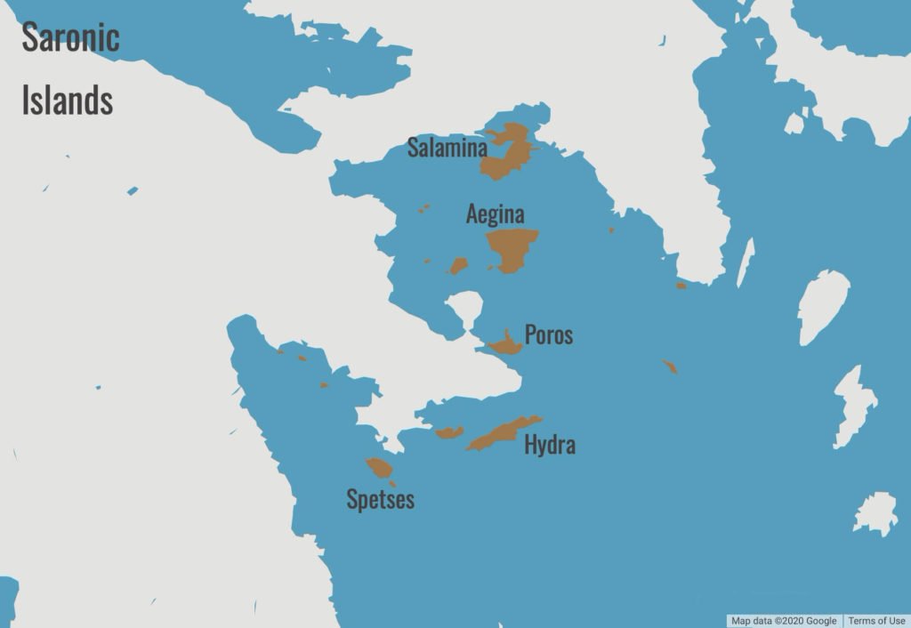
The Saronic Islands
This cluster of islands, named after the Saronic gulf within which they are located, are very popular vacation spots amongst the Greeks. Particularly convenient, within a short ferry ride from Athens’ Piraeus port and various towns along the Peloponesse coast. Many Greeks have holiday homes on these islands and frequently visit for short breaks and weekends.
The main islands include;
- Aegina – an important island of ancient Greece
- Hydra – car-free and unspoiled
- Poros – with its lush greenery, and
- Spetses – the place to be seen
All differ in their character, yet all are popular with various crowds. From creative types, the rich and famous and families alike. The seafront promenades and main Chora’s are lively on the weekends and particularly throughout the summer months.
The proximity to Athens makes this island group a solid alternative to the Cyclades for those visiting the main highlights of Greece. Particularly suitable for those wanting to partake in some island hopping away from the large crowds.
Map of the Greek Islands – Saronic Island Group
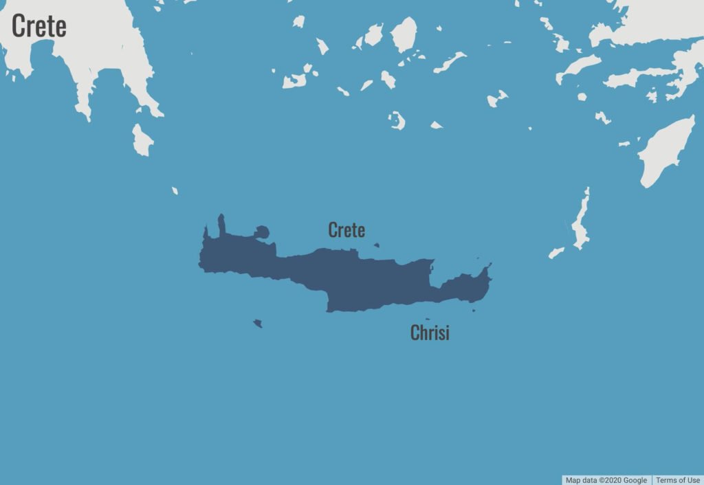
Crete
The largest island in all of Greece is Crete, with its elongated shape stretching East to West. The island demarcates the end of the Aegean Sea and the start of the Libyan Sea.
Hugely popular with the package holiday-makers as well as those seeking to explore a little more independently. The island, being one of Greece’s largest municipalities and one of it’s most popular tourist destinations, has three airports. Of which two are international and served by various cities throughout Europe.
Crete has World famous beaches dotted around the island and remains of the earliest advanced civilisations in Europe. Not to be overlooked, the Cretan cuisine is recognised to be some of the best in Greece.
Map of Crete Island


Hello! I just would like to give a huge thumbs up for the great info you have here on this post. I will be coming back to your blog for more soon.
Thanks Subert!
It’s a shame you don’t have a donate button! I’d certainly donate to this excellent
blog! I guess for now i’ll settle for bookmarking and
adding your RSS feed to my Google account. I look forward to fresh updates
and will talk about this blog with my Facebook group. Talk soon!
Thanks Kristopher. More coming soon!
Hi Gina – Thank you for all this wonderful info. I’m trying to plan a mother daughter college graduation trip and you have really helped me. I still have no idea where we will go but this is great info.
Thanks Allyson
Hi Gina – Thank you for all these Greek Island information, this year we have been to Santorini and we enjoyed it and i am looking forward to Island hopping via Ferry hopping, not sure where to start from, we leave in UK. Our main aim to cover 3 nights each Island, Mykonos, Milos, Kos, Naxos and Paros these are on top of the list. Is this possible to hopping these Island in one trip. please advise Many thanks.
GREECE ISLANDS,,,,,,,,,THERE IS NO PLACE ON THIS PLANET LIKE THE GREEK ISLANDS